FULL REFERENCE:
Chabot, N. L., Ernst, C. M., Paige, D. A., Nair, H., Denver, B. W., Blewett, D. T., Murchie, S. L., Deutsch, A. N., Head, J. W., and Solomon, S. C. (2016) Imaging Mercury's polar deposits during MESSENGER's low-altitude campaign. Geophysical Research Letters 43, doi:10.1002/2016GL070403.
ABSTRACT:
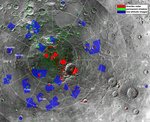
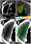
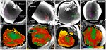
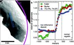
Images obtained during the low-altitude campaign in the final year of the MErcury Surface, Space ENvironment, GEochemistry, and Ranging (MESSENGER) mission provide the highest-spatial-resolution views of Mercury's polar deposits. Images for distinct areas of permanent shadow within 35 north polar craters were successfully captured during the campaign. All of these regions of permanent shadow were found to have low-reflectance surfaces with well-defined boundaries. Additionally, brightness variations across the deposits correlate with variations in the biannual maximum surface temperature across the permanently shadowed regions, supporting the conclusion that multiple volatile organic compounds are contained in Mercury's polar deposits, in addition to water ice. A recent large impact event or ongoing bombardment by micrometeoroids could deliver water as well as many volatile organic compounds to Mercury. Either scenario is consistent with the distinctive reflectance properties and well-defined boundaries of Mercury's polar deposits and the presence of volatiles in all available cold traps.
PMCID 5606156
https://www.ncbi.nlm.nih.gov/pmc/articles/PMC5606156/
ACKNOWLEDGMENTS
The MESSENGER project is supported by the NASA Discovery Program under contracts NAS5-97271 to The Johns Hopkins University Applied Physics Laboratory and NASW-00002 to the Carnegie Institution of Washington. Support was also provided by the MESSENGER Participating Scientist Program (NNX07AR64G to D.A. Paige and NNX08AN29G to D.T. Blewett) and NASA Discovery Data Analysis Program grant NNX15AK89G to N.L. Chabot. This research made use of the Integrated Software for Imagers and Spectrometers of the U.S. Geological Survey. All data analyzed in this paper are archived at the NASA Planetary Data System.
| Preview | Filename | Description |
|---|---|---|
|
2016gl070403_fig1.tif |
Full resolution file of Figure 1 provided to GRL |
|
2016gl070403_fig2.tif |
Full resolution file of Figure 2 provided to GRL |
|
2016gl070403_fig3.tif |
Full resolution file of Figure 3 provided to GRL |
|
2016gl070403_fig4.tif |
Full resolution file of Figure 4 provided to GRL |
|
|
2016gl070403_tables1.xlsx |
Table S1, in excel format |
|
|
2016gl070403_tables1.pdf |
Table S1, in pdf format |
|
|
tables2.xlsx |
Table providing the filename, latitude, longitude, acquisition date and time, and resolution of the 402 MDIS low-altitude images that revealed features with permanently shadowed craters. |
|
|
fig1_lowalt_fig1crop2.psd |
Photoshop file used to layout and label Figure 1 |
|
|
fig2_desprez_ver5.psd |
Photoshop file used to layout and label Figure 2 |
|
|
fig3_lowalt_manyver4.psd |
Photoshop file used to layout and label Figure 3 |
|
|
fig4_transect_graphlowaltver2.psd |
Photoshop file used to layout and label Figure 4 |
|
|
fig4b_data.xlsx |
Data shown on the graph in Fig. 4b |